Ray Brandes, Ph.D. The Costanso Narrative of the Portola Expedition, Hogarth Press: Newhall, CA, 1970, 112 pp.
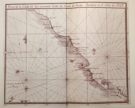
Costanso’s 1769 Map of the California’s Coast up to the Santa Barbara Channel.
"The map appearing as endpapers (inside cover) was the first map to show the observations carried out by the Portola expedition and reported by engineer Miguel Costanso in his letter to Don Jose de Galvez—the man responsible for the expedition which founded California. It is a map of the California coast "corrected up to the Santa Barbsra Channel" and drawn by Jorge Storace sailing master on the San Carlos in 1769."